Modélisation 3D par Drone
Un moyen innovant et précis pour vos projets
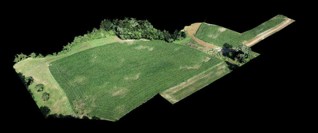
La modélisation 3D par drone est une technologie innovante qui fournit des données précises et des visualisations hautement détaillées de sites et de structures. Avec une précision, une rentabilité et une efficacité inégalées, la modélisation 3D par drone est un outil incontournable pour les professionnels de nombreux secteurs, dont l’immobilier, l’industrie et la conservation du patrimoine.
Pourquoi opter pour la modélisation 3D par drone ?
La modélisation 3D par drone offre des avantages considérables par rapport aux méthodes traditionnelles de relevé et de modélisation. En utilisant des drones, nous sommes en mesure de capturer des images de haute résolution de n’importe quelle structure ou site, en toute sécurité et efficacement. Ces images sont ensuite transformées en modèles 3D détaillés, fournissant une visualisation précise qui peut être utilisée pour une multitude d’applications.
Les promesses de notre prestation de Modélisation 3D par drone
En combinant notre expertise dans l’utilisation de drones avec des caméras thermiques avancées, nous offrons une gamme complète de services de thermographie par drone pour répondre à vos besoins spécifiques.
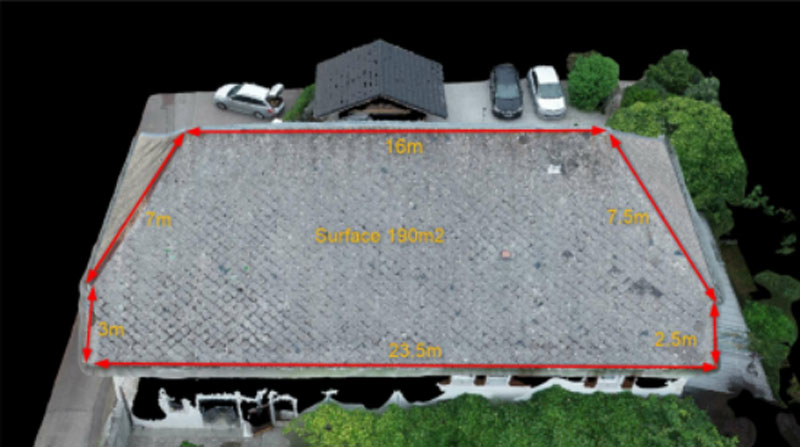
Précision inégalée
Grâce à nos drones de pointe et à nos logiciels de modélisation 3D, nous pouvons créer des modèles extrêmement précis qui captent chaque détail d’une structure ou d’un site.
Efficacité exceptionnelle
La modélisation 3D par drone nous permet de collecter des données rapidement, réduisant ainsi le temps nécessaire pour obtenir les informations dont vous avez besoin.
Sécurité améliorée
En utilisant des drones pour capturer des images, nous éliminons le besoin d’accéder physiquement à des zones potentiellement dangereuses ou difficiles à atteindre.
Les applications variées de la modélisation 3D par drone
La portée des applications de la modélisation 3D par drone est vaste, ce qui rend cette technologie d’autant plus précieuse.
Dans le secteur immobilier, par exemple, les modèles 3D de haute précision peuvent transformer la façon dont les propriétés sont présentées à des clients potentiels. Les visites virtuelles peuvent être créées, donnant aux acheteurs potentiels la possibilité d’explorer une propriété en détail, peu importe où ils se trouvent dans le monde. Cela peut contribuer à accélérer le processus de vente ou de location, tout en offrant une expérience client améliorée.
Pour l’industrie, la modélisation 3D par drone offre une précieuse opportunité de planification, de simulation et d’optimisation de la production. Les modèles 3D permettent aux ingénieurs et aux gestionnaires de visualiser l’installation de production sous tous les angles, de simuler les changements potentiels et d’identifier les zones d’amélioration. Cela peut contribuer à une plus grande efficacité opérationnelle et à une meilleure prise de décision.
En ce qui concerne la conservation du patrimoine, la modélisation 3D par drone est un outil précieux pour la préservation des sites historiques. En créant des archives digitales détaillées, nous pouvons aider à documenter et à préserver ces précieux sites pour les générations futures.
Un expert vous rappelle !
Contactez-nous dès aujourd’hui pour découvrir comment nos services de modélisation 3D par drone peuvent bénéficier à votre entreprise ou à votre projet. Notre équipe d’experts est prête à répondre à vos questions et à vous aider à atteindre vos objectifs.